


 Boiler Bay Beacon

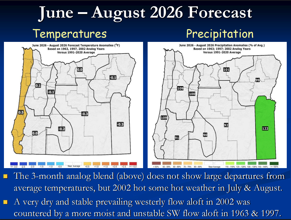
Oregon’s central coast and much of the state are looking at a return to more typical summer weather this year, according to the latest Seasonal Climate Forecast from Pete Parsons.
Issued May 23 by the Oregon Department of Forestry’s lead meteorologist, the outlook looks back at three past years that had similar ocean patterns to what we’re seeing right now (1963, 1997, and 2002). It doesn’t try to factor in the separate forecast from NOAA that’s calling for El Niño to show up and maybe get pretty strong later this year and into winter.
Put those three years together and you get a pretty average summer for temperatures and rainfall across most of Oregon. The big weather pattern aloft is leaning more toward troughs of low pressure than strong high pressure, which usually means it won’t get as hot or as bone-dry as it can in some summers.
July is the trickiest month to call because those three years were pretty different from each other. August has the best shot at running a little warmer than normal, especially in the valleys, and there’s a decent chance of some showers or thunderstorms popping up depending on which way the wind blows.
June should come in a touch cooler than average in a lot of western Oregon, with rainfall right around normal. Nothing wild expected.
July is where the years disagree the most, so confidence is lower. Temperatures will probably land close to average or just a bit below, and rain chances look decent in a few of the past years.
August is the one that could feel a little warmer, mainly inland. One of those past years had a stretch in the middle of the month where valley temperatures climbed over 100 degrees. Along the coast the ocean usually keeps a lid on that kind of heat.

Here on the Central Coast
Lincoln City and the rest of the central coast should get the usual summer deal. Think highs mostly in the mid-60s, cool nights, morning fog that burns off by afternoon, and mostly dry weather with just a passing shower now and then. The ocean keeps things from getting too extreme either way.
That’s pretty good news if you’re planning beach time, hikes, or just hanging around town. Fire risk should stay in the normal range for summer, and we’re not looking at any big red flags for water supplies from this forecast.
These are seasonal averages, not day-by-day predictions. Weather can still jump around a lot from one week to the next. The three years Parsons used don’t line up perfectly, especially in July, so things could shift.
For day-to-day planning, stick with the National Weather Service forecasts. These longer-range outlooks get updated every month.
- Full forecast with all the maps: https://www.oregon.gov/oda/natural-resources/Documents/Weather/forecast.pdf
- Pete Parsons at ODF: 503-945-7448 or [email protected]
It’s shaping up like a pretty normal Oregon summer. Nothing too crazy on either the hot or the wet side. Whether you’re local or just coming to the coast for a visit, that’s usually the kind of summer people like around here.


